Thursday, September 6, 2012

19 Cities: Final Thoughts

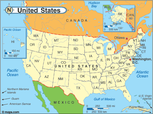
Each push pin on this map shows a place I stopped on my travels to snap photos.

Since I began this blog about a year and a half ago, I have had the privilege of visiting and learning about nineteen cities in this great land of ours. And because traveling is an excellent way to expand one’s knowledge about people and places, I have dramatically increased my understanding of the United States and its amazing cultural and geographic diversity. Excepting my ventures to Juneau, Alaska and Honolulu, Hawaii, I chose to drive to each city from my home in Virginia so that I could see more of our “spacious skies, amber waves of grain, and purple mountain majesties above the fruited plains” as the song, “America the Beautiful” describes. I would have driven to both Juneau. Alasks and Honolulu, Hawaii as well, but neither is accessible by car. The map above, covered with red pushpins provides a snapshot of my travels.

As a result of maintaining this travel blog, I have now fulfilled a lifelong goal of visiting every one of our fifty states. In the past eighteen months I’ve driven over the Rocky Mountains, dipped my toes into the Great Salt Lake and the Pacific Ocean, witnessed a glacier calving, watched whales spouting, ridden a ferry across Puget Sound, viewed the Hollywood sign from atop the Griffith Observatory, learned how TV news is created each day, stood in the room where the First Continental Congress met, took a paddle wheel ride down the mighty Mississippi River, zoomed across the Everglades in an airboat, motored across the Golden Gate Bridge, went face to face with a saber-toothed cat skeleton, strolled amongst ancient majestic redwood trees, commanded the view of a huge city from atop a towering skyscraper, enjoyed a breathtaking live performance at the famed Lincoln Center, stood on the very spot where legendary Motown hits were recorded, sped on an express train from the suburbs into the heart of a major city, and zipped to the top of the largest man-made arch via a tram. And that was just for starters.

Traveling is one of the best ways I know to learn and have new experiences while broadening one’s horizons. Getting bitten by the travel bug affords a person a multitude of opportunities. Although places may vary, people across our nation share much in common. In each and every location I visited while writing this blog I learned that everyone has the same basic needs and desires: a safe place to live, high quality education, excellent affordable healthcare, access to nutritious food, as well as clean air to breath and pure safe water to drink. So, no matter how different each of us thinks we are, basically we Americans are all the same across the far flung corners of this nation. And in my vast international travels, I have found this to be true across our globe, too. In every place I have visited over my long life—including a multitude of foreign countries—I have found people who are kind and caring and respectful of others, people who freely reach out to help a stranger. I believe it is important to keep this as our focus as we learn more about our world.


Wednesday, September 5, 2012

Denver: The Mile High City


Denver sits one mile above sea level as measured against the level of the Gulf of Mexico. This explains why Denver is called the Mile High City. It is the capital of Colorado and also its largest metropolitan area. Surrounded by the Rocky Mountains, Denver is America's 23rd most populous city.

The steps to the capital show where surveyors in the late 1800s determined the city to be 5,280 feet above sea level (one mile).


As Colorado's capital city, Denver contains the seat of the state government, which meets in the capitol building for several months each year. The capitol is currently undergoing renovations, and you can see the scaffolding along the left side of the photograph. Covered in gold, the capitol dome is reminiscent of the dome of our nation's capitol in Washington, D.C. [Note: When capital is spelled with an "al" at the end, it refers to the city. When there's an "ol" at the end, it refers to the building.]


The fittest state in the Union, Denver emphasizes being green, that is, working hard to take care of the environment. You can traverse the entire city on bicycle paths, and you can even borrow a bike for free for thirty minutes from several bike stations scattered throughout the city. After the first thirty minutes, you must pay a rental fee. Using bicycles helps you stay fit while also not polluting the environment.
 
 
The people of Denver love the outdoors, and while I was there the temperature was in the 90s. This has been the hottest summer on record across America and Denver has had more continuous days above 90 degrees than in recorded history.

A Taste of Colorado
For more than thirty years, Denver has held a huge street festival called "A Taste of Colorado". It is a is a  four-day music and entertainment celebration held each year during Labor Day weekend. The festival features more than 50 food booths, about 300 vendors and artisans, six entertainment stages with live shows, and educational programs that promote both the diverse culture and western heritage of the Denver area.
 
Denver's Union Station
The railroads had a huge impact on the settlement and growth of the West. Originally built in the late 1800s, at one time Union Station served as the railroad hub of Denver with more than 80 trains coming and going each day. When people made the shift from trains to cars, the old station fell out of use. Currently, under renovation, Union Station soon will be utilized as a light rail hub.

While in Denver, I ate at a restaurant well known for its entertainment and food. In the photograph below, you can see the dessert of fried ice cream that I was served. Below the image of the fried ice cream, you will find a short video illustrating one example of the restaurant's entertainment. Inside is a 35' cliff with a 14' deep pool below. Every fifteen minutes while I was there, someone dived from the cliff.


This was the first time I ever ate fried ice cream. It was delicious.


Built in the late 1800s and now spanning three centuries, another restaurant in Denver is well known for its exotic menu. Featured menu items include elk, buffalo, quail, Cornish game hens and even yak and ostrich when they are available. The building has its original tin ceiling and is reminiscent of the old west. In the photograph below you can see the unusual decor.


Finally, a trip to Denver would not be complete without a visit to Hammond's Candies, one of the few remaining candy companies that creates and packages everything by hand. The 120 employees make 2,000 - 3,000 pounds of candy each day and 2,500,00 candy canes each year ... all by hand ... 70 pounds at a time. Visit this website and scroll down to watch a video, A Mile High Highlight!, illustrating candy making in progress: http://www.hammondscandies.com/factory-tours-parties You can purchase Hammond's candy at many retail outlets across the USA.

All in all, Denver is a clean city with much to offer visitors. It has more public parks than any city in America. And not far out of town the great outdoors awaits.

Tuesday, September 4, 2012

Denver: The Unsinkable Molly Brown


Perhaps you have heard of the Unsinkable Molly Brown, a famous woman who survived the sinking of the Titanic. Stage plays and movies have emphasized much of the lore about her life, but the true story is much more interesting. For her day, Margaret Tobin Brown was one of the most forward thinking, accomplished and energetic women in America, and she is one of Denver's most famous historical figures.

Margaret "Molly" Tobin Brown
Born into a family of modest means, Margaret Brown was fortunate to have parents who believed it was important for girls to become educated at a time when this was fairly rare. Finishing school at thirteen, Margaret joined her father working in a factory where she learned firsthand about the long hours, unsafe working conditions, and low pay that were acceptable practices during that era. Unions were not allowed and workers had no rights.

At 19 Margaret met and married J. J. Brown, a mining engineer who eventually struck it rich through gold mining. The Browns quickly became millionaires, and they purchased a sumptuous home on Pennsylvania Avenue in Denver. Today the home, pictured below, is a historical site and serves as a museum.


Much more was to come in the life of Margaret Brown. She did survive the sinking of the Titanic and earned her nickname when she reportedly stated, "Typical Brown luck; we're unsinkable." But more importantly, Mrs. Brown worked tirelessly on behalf of those less fortunate, particularly indigent children who suffered in grinding poverty. There is an old saying that a chain is only as strong as its weakest link. So our country progresses and does better when everyone's life improves.

Margaret Brown continued her work as an activist during the Progressive Movement. Also a philanthropist, she fought hard for workers' rights and on behalf of Women's Suffrage. Speaking out about injustice and the need for women to have the right to vote, Margaret Brown battled tirelessly for workers to gain both a minimum wage and an eight-hour work day. Prior to these hard-won rights, workers were required to work twelve or more hours a day, usually for a pittance.

When World War I broke out in 1914, Margaret put her energies into relief efforts for those who had suffered the ravages of the war. In France, she was awarded the French Legion of Honor for her work with the American Committee for Devastated France. Later, she became part of the cultural renaissance, and after moving to New York--she did keep her house in Denver--Margaret performed on stage in both Paris and New York. Margaret Tobin Brown passed away in her sleep in a New York hotel in 1932. She had lived life to the fullest while helping those less fortunate along the way. The impacts of her life are still felt by Americans today who enjoy an eight-hour work day, a minimum wage, and by women who freely vote.

Denver: The Mint

We all use money and handle it a multitude of times throughout our lives. But many of us never think about the money that passes through our hands whether it be paper currency or coins. Can you name the denominations of all the money currently in circulation in the United States? Do you know who is being honored on each one? For each coin or bill can you describe what is on each side as well as what it means or represents? Do you know where and how it is made? All of the money our country produces has an interesting history, and it is worth learning about.
 

Do you know what this coin is? Who's image is on it? Find the date at the bottom right. What letter is under the date? What does it mean, and why is it there? The "D" stands for Denver, the city where the coin was minted. Coins have been struck at the current Denver Mint since early 1906. If you visit Denver, you can take a tour of the Denver Mint to see in person how coins are created. You also can see the process for minting coins by visiting this website: http://www.usmint.gov/faqs/circulating_coins/index.cfm?action=coins

Denver Mint
The largest producer of coins in the entire world is in Denver, Colorado. Here all denominations of United States circulating coins are made as well as coin dies, uncirculated coin sets, and other commemorative coins that have been authorized by the United States Congress. These are all legal tender, that is, money that you can spend. In addition, both gold and silver bullion are stored at the Denver Mint.

The history of how it all began in Denver is fascinating. Gold was discovered in Colorado in 1858 causing adventuresome individuals to head for the Rocky Mountains. Settlers, miners, and merchants arrived in Denver hoping to capitalize on the discovery. By 1859, the city of Denver was founded and began to grow. As miners found gold, they would bring it to an assay office to have it evaluated for quality and then melted and cast into ingots. The gold bars were then stamped showing both their weight and the quality of the gold. As a result, the United States government established the Denver Branch Mint facility in 1863, but it only served as an assay office for 46 years and did not mint coins. Both gold and silver continued to be mined in Colorado throughout the latter part of the 1800s, so much so that by 1895 more than $5,600,000 in these precious metals were assayed in Denver each year. Outgrowing its facility in a local Denver bank, in 1896 the government purchased a site to build a new Denver Mint.

In 1904, the US government converted the Denver Assay Office into a working mint that strikes coins. To meet this need a larger facility--the one in the photo above--was erected on the new site, and by 1906 it was in full operation. In its first year alone, the new Denver Mint struck more than 167,000,000 gold and silver coins. Today the Denver Mint has the capacity to produce 50,000,000 coins per day.


Colorado State Quarter
Throughout the history of the United States, there have been many mints in various cities across the country, but most are no longer in operation. Today, the US Mint maintains these facilities in addition to the Denver Mint: 
  • United States Mint Headquarters in Washington, DC
  • United States Mint in Philadelphia, Pennsylvania
  • United States Mint in San Francisco, California
  • United States Mint in West Point, New York
  • United States Bullion Depository in Fort Knox, Kentucky.
If you have an interest in coins, you can begin a collection. I began one when I was ten, and I continue to add to the collection today. It is an interesting and enjoyable hobby, and some of my favorite coins were ones I received in change after making a purchase. Coin collectors are called numismatists. Here are a few fun facts about coins that I have learned over the years while collecting coins:

1. Originally laws required that all United States coins to be made of gold, silver, or copper but that changed in the 1960s. Today's coins are made of nickel, zinc, and copper.
2. From 1942-1945 five-cent coins contained no nickel and instead were made from an alloy because nickel was needed for the war effort.
3. Pennies made before 1909 were called Indian Heads because the image on the coin was an Indian chief.
4. From 1856-1858 there were pennies called "white cents" made from copper and nickel. 
5. After 25 years in usage, a coin design can be changed by order of the Secretary of the Treasury. 
6. "Wheat pennies" were coined from 1909 to 1958 when the backs had wheat stalks on them.
7. In 1943 pennies were made of steel and turned a dark gray. 
8. A coin will last in circulation for about 30 years. 
9. The first commemorative coin was made in 1892 to celebrate the Columbian Exposition.
10. When the first Lincoln penny was minted in 1909, it had the designer's initials at the bottom in tiny letters. VDB stood for Victor D. Brenner.

Tuesday, August 28, 2012

Salt Lake City: I Found My Great Grandmother At The Family History Library


Family History Library

Have you ever wanted to be a detective, using clues to solve mysteries? Ever since I began watching History Detectives on PBS, I have thought it would be an interesting career. But you don’t have to have a job as a detective in order to be one. I found out in Salt Lake City that you can be a sleuth right in the privacy of your own home.

Years ago, official documents were handwritten like this birth certificate from 1880. None of the documents in this blog entry are from my family, but I did find them at the Family History Library.
Governments collect information, and they keep careful and detailed records. As an example, when you are born you receive a birth certificate and your birth becomes part of the public record. The same is true when you die. Military records are another source as are census forms. In fact, our government has over 4,000,000,000 documents in the National Archives. Most document records were kept on paper, while others made their way onto microfilm or microfiche. In years prior to the digital age, if you wanted to search for a birth record in Massachusetts, you had to go to Massachusetts or write to the state and request information. Now, however, these government records are in digital format and are available online. And you can access them from home.

You can better understand your own life when you learn about your ancestors. A piece of every one of them is part of who you are. Most of us know who our parents are and also our grandparents. Beyond that, it can be hard to tell. Of course, you can ask your parents and grandparents for information, but many don’t know or they have forgotten or perhaps they have information that isn’t completely accurate. 

This ship manifest lists all ship passengers and provides a lot of information about the immigrants coming into Ellis Island for processing. It lists names, country of origin, and so on.
Unless you are a Native American, your ancestors came here from somewhere else. During the great wave of migration, one set of my great grandparents arrived by ship in America in the late 1800s. My niece recently sent me a copy of the ship’s manifest showing my great grandparents’ arrival from Germany at Ellis Island in New York. She found it on the Ellis Island website, an easy place to being searching for information about your family. And because the ship’s manifest document was in digital form, my niece was able to print hard copies for her family records and for me. 

Every ten years the United States government counts all of its citizens. This page from an old census book lists everyone who lived at a particular address along with their ages and occupations. I found the record for my mother's family from 1920 when was was still a baby and again in 1930 when my mother was twelve.
A number of years ago, my parents gave me copies of photographs of many of my ancestors, but they knew very little about them. While I was in Salt Lake City, I decided to go to the Family History Library for help in finding out about some of my family history. I was surprised to learn that the library provides free access to its vast resources, and volunteers are there to help you get started. I only had an hour to spend, but in that short time I found my great grandmother! All I knew was her name and that she possibly was from Massachusetts. The volunteer asked me when my great grandmother was born, but I did not know. She asked if I knew when my grandmother, my great grandmother's daughter, was born. I said it was in 1882. The volunteer suggested that I search census records for 1870 because my great grandmother probably was listed in that census. Within a few keystrokes, I found the document showing that my great grandmother and her brother lived in a small town in Massachusetts in 1870. And now I also know the name of my great grandmother’s brother. Prior to this I had no idea that my great grandmother had a brother. The volunteer next had me enter the names of each of my grandfathers, and a quick search returned two documents. Was I surprised to see my grandfathers’ signatures on the documents! I made copies to take home with me. Then, the volunteer showed me how to use the online resources when I get home. And she said that if I need more help, I can go to a center near to my hometown where volunteers will guide me. As soon as I get back home, I am going to become my own history detective. I cannot begin to imagine all that I will find. Now that I have found my great grandmother listed in the 1870 census, I may be able to find her in the 1850 census. And because in 1850 my great grandmother would would have been only six years old, it is likely that I will find out the names of her parents and any other siblings because all members of a family are listed together in census documents.

When a person dies, the death is registered and a death certificate is issued. Generally, you need this document to make a claim on life insurance.
What would you like to know about your family? Did your great-great grandfather serve in the Civil War? Did your great grandmother come to America from Italy or France or Germany? If you want to find out, begin by visiting this website: www.familysearch.org. In addition to searching online, the site lists centers where you can go for help. I found one that is only twenty miles from my house.

This is an example of a draft registration card from World War II. While I am not related to this person, I was able to find copies of the ones my grandfathers filled out complete with their signatures.
Happy sleuthing and don’t be surprised if you find something amazing.

Monday, August 27, 2012

Salt Lake City: The Great Salt Lake and Antelope Island


If you look at this map of the United States, you will readily see the Great Salt Lake in Utah, the largest lake in the US west of the Mississippi River. Only the Great Lakes are larger. But this was not always so because the Great Salt Lake is a small remnant of the huge Ice Age Lake Bonneville, which encompassed 20,000 square miles. By comparison, the Great Salt Lake today comprises only 2,000 square miles. Still, it is massive enough that the entire state of Rhode Island and the Hawaiian Island of Oahu could fit inside the lake with room to spare.

The Great Salt Lake
Most lakes contain fresh water, but because it has no outlet, the Great Salt Lake is filled with water so salty that in some parts the salt content is 25%. Imagine filling a glass ¼ full of salt and then adding water to the top of the glass. The lake is divided into three parts--the southern arm, the northwest arm, and the northeast arm. Because it is so salty if you swim in the Great Salt Lake you can easily float. Some folks look like corks as they bob about in the water. 4.56 billion tons of salt are dissolved in the lake with about 2.2 tons of salt—about as much as would fill 70,000 railroad boxcars—added each year. Salts and other minerals are carried into the lake by three rivers and smaller streams that empty into the lake. Salt settles to the bottom of the lake and over time  can create large crystals like the one in the photograph below. 

Salt crystal from the Great Salt Lake
Situated in the Great Salt Lake is Antelope Island, named for the antelope that once roamed there.  It is the largest of the ten islands located in the lake, and is now a state park. Two-thirds of the island is formed of gneiss, a hard metamorphic rock that is about 2.7 billion years old, ten times as old as rocks from the age of early dinosaurs. 

Gneiss (pronounced as "nice") is a metamorphic rock with bands of minerals clearly visible.
Rock formations like this are common on Antelope Island.
For more than 100 years, bison have lived on Antelope Island. At present the population numbers between 500 and 700. Each year the bison are rounded up and checked by veterinarians. And to thin the population about 150 bison are auctioned each year. Otherwise, they roam freely. In addition to the bison, millions of native birds, including waterfowl reside there. And what about that salty water? Fish cannot survive in the lake because the water is too saline. But the lake is filled with tiny brine shrimp, an important component of the ecosystem that serves as food for the billions of brine flies that swarm around the lake, sometimes forming a black cloud. While adult brine flies live for only a few days they are the primary food source for the birds. In addition, dozens of species of bacteria, protozoa, and algae thrive in the lake. More than 400,000 acres of wetlands around the lake’s shore provides important nesting grounds for the multitude of birds that live on the island. Some of the species of birds that are dependent on these wetlands are the bald eagle, peregrine falcon, eared grebe, California gull, white-faced ibis, American white pelican, tundra swan, western sandpiper, snowy plover, American avocet, along with huge numbers of geese and ducks.

If you look very carefully, you can see tiny brine shrimp in this photograph. They are the small white creatures near the center and bottom.
This sign warns motorists to stay on the road and to keep away from the buffalo.
Some buffalo on the island form herds.
Others wander about alone.
Antelope Island is a Utah state park and is now accessible by automobile on a seven-mile causeway to the island.

Seven-mile causeway to Antelope Island
The Great Salt Lake at sunset

Sunday, August 26, 2012

Salt Lake City

Look at this logo representing Utah, our 45th state. What does it tell you? Yes, Utah has mountains and is known for snow skiing. In fact, the 2002 Winter Olympics took place in Utah in and around its capital, Salt Lake City. Utah has almost 3,000,000 residents and 80% of them live in the Salt Lake City area along the Wasatch Front. But Utah and Salt Lake City are known for much more than sports and recreation. Nicknamed the Beehive State, the people of Utah admire industriousness. And because of their hard work, Salt Lake City grew and thrived.


The photograph below shows Salt Lake City and the surrounding mountains. The city was named for the Great Salt Lake, the largest lake west of the Mississippi River. It is easy to find on a map of the United States.


What does transcontinental mean? Trans means across, so transcontinental means stretching from coast to coast across this great country of ours. Our nation's first transcontinental highway, the Lincoln Highway cut through Salt Lake City giving it the nickname Crossroad of the West. Mining booms--the largest copper mine in the world is located right outside Salt Lake City--and the building of the Transcontinental Railroad helped Salt Lake City grow. Today it is the industrial banking center of the United States.


Prior to the arrival of American settlers, native tribes lived in the Salt Lake area for thousands of years. Then, in 1847 a group of Americans seeking religious freedom made the trek across the country to establish and settle in Salt Lake City. Some were so desperate to come that they put all of their belongings in handcarts and pulled them across the country. The statue above commemorates these rugged individuals who walked hundreds of miles to reach their new home. As I traveled to Salt Lake City in an air-conditioned car across miles and miles of desert land, I found it a bit tiring. Then, I tried to imagine what it would be like to walk the entire way in the hot sun while pulling all of my belongings in a handcart. I do not believe I would have the stamina. Would you?

The first place I visited was Temple Square in downtown Salt Lake City. I was struck by the profusion of flowers; they were everywhere. 


The two buildings above comprise part of Temple Square. The one on the left with the shiny domed roof is the Mormon Tabernacle, a type of church. Perhaps you have heard the Mormon Tabernacle Choir sing. Their beautiful voices blend together perfectly. The large granite structure on the right is the Temple, built in the 1800s over a forty-year period. Also in Temple Square is Assembly Hall built from leftover granite after the Temple was finished. You can see Assembly Hall below. It was completed in 1880, and originally the tall spires did not have the white caps because they were chimneys.


In the mid 1800s, before Utah became a state, it was a U. S. Territory. During this time Brigham Young served as governor and lived in the Beehive House. In addition to living quarters, his home had a room called the Clerk's Office. It was used to house government records. Also, the telegraph--the main form of long distance communication at that time--and the post office were part of the Clerk's Office.


Beehive House
Imagine writing letters  or doing your schoolwork on this old typewriter. It sat on the desk that had served as the Clerk's Office.

Bathrooms are a modern convenience, and the Beehive house had none. Prior to homes having running water, people used large  water pitchers to fill basins to wash themselves. And, because there were no toilets, people used chamberpots like the ones you see here on the floor. Each day the chamberpots had to be emptied. Would you like to have that chore?

After I left Temple Square, I made my way across town to visit two interesting sites: Red Butte Gardens and the Utah Natural History Museum. Both are situated on the University of Utah campus. As I walked to the garden I saw a sign reminding me to watch out for rattlesnakes, and while in the garden I saw a couple of rattlesnakes, but these weren't live. 

This sign was not a joke. Rattlesnakes love the terrain in and around Salt Lake City.

I saw a few rattlesnake fountains like this one. Can you see the stream of water shooting from the snake's mouth?

See if you can find the snake in this shady rest area. Where are the fangs? The snake's tongue?


As a gardener, I loved my visit to Red Butte Garden. I couldn't help but wonder why my own flower beds don't look as beautiful considering how much work I put into them. When I left the garden, I walked across the street to the Utah Natural History Museum where I viewed a variety of interesting exhibits.


An entire floor of the museum was devoted to the native cultures who lived here prior to the arrival of American settlers.

There are 523 kinds of minerals found in Utah; at least that is how many have been identified so far. The diversity of minerals is amazing, and some of them are found nowhere else in the world. Here is a specimen of aragonite, a carbonite mineral.

This big boy was a distant relative of the alligator that lived 73-80 million years ago. He was so huge that he was about as long as a school bus. Imagine running into something like that! His scientific name is deinosuchus hatcheri.

If you like dinosaurs you might like this beast. He, too was about as long as a school bus and weighed 4,400 pounds. Those teeth are many inches long. Chomp.

Like many modern science museums, this one has a Paleontology Preparation Lab where workers carefully extract fossils from matrix materials. The work is tedious and time consuming.

As I was leaving, this exhibit caught my eye.
I was shocked by what I learned, and I hope you are, too. All of us must take proactive steps to remedy this problem. Here are some amazing statistics I learned from the exhibit above: 
  • In 2010 we used 28,000,000,000 pounds of plastic packaging. 
  • Every second in the USA 1,500 plastic water bottles are tossed out. 
  • Those pesky plastic bags we get at the grocery store (if we don’t take our own reusable bags or request paper) are a huge problem. 
  • We send 1,000,000,000,000 plastic bags per year to landfills or other dumpsites. 
  • Of course, the earth cannot “digest” plastic, as it does not biodegrade. One plastic bag will last up to 1,000 years. 
  • Trash is filling our oceans, so much so that in the Northern Pacific, there is a mass of trash that is larger than the state of Texas! 
  • Every year 1,000,000 sea birds and 100,000 marine mammals and sea turtles die when entangled in plastic pollution or when they ingest it. 
Please think about this the next time you go to the store or reach for a bottle of water. I cannot imagine what Earth will be like if we continue this unabated. What steps will you take to do your part to save our earth?